


SkyDemon
SkyDemon의 설명
SkyDemon 탐색 VFR 비행 계획 및 비행 중 유럽에서 가장 인기있는 솔루션 중 하나입니다.
이동하는 동안 SkyDemon의 강력한 기능을 잠금 해제, 안드로이드 장치에 SkyDemon 가입에 액세스하려면이 응용 프로그램을 사용합니다.
비행 계획의 특징
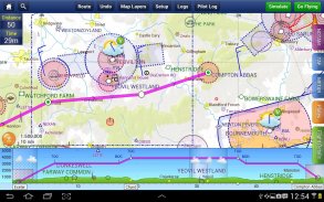
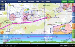
- SkyDemon 벡터 차트는지도 레이어의 동적 영공 클리핑과 선택에 당신이 이제까지 사용합니다 깨끗한 항공 차트입니다
- 루트 계획은 연속 웨이 포인트를 터치하고 변경을 드래그하는 것만 큼 간단
- 경로가 영공, 지형, 장애물 및 기타 기능에 관한 방법을 가상 레이더 보여줍니다
- 파일럿 로그 기능은 실제 바람 데이터에서 제목과 groundspeeds을 계산하고 유용한 주파수를 보여줍니다
- 관련 비행장에 대한 플레이트 및 기타 문서는 당신이 계획대로 자동으로 표시하고, 많은 비행에서 사용할 수있는 지리된다
- 직관적 팬, 핀치 및지도 선명도 또는 텍스트 가독성의 손실없이 지원을 회전
- 항공 교통 컨트롤러에 직접 경로에 대한 VFR의 플라이트 파일
- 자동 TAF, METAR와 SIGMET 브리핑 당신은 그래픽 디코딩으로, 경로를 계획
- 강우 데이터는 시간이 지남에 따라 강우량의 추세를 보여주는, 애니메이션, 주요지도에 오버레이 할 수
- 스위스, 오스트리아, 슬로베니아와 크로아티아에 대한 GAFOR 경로 예측의 통합
- 당신이 계획에 따라 업데이트 가능한 좁은 경로 및 지역 NOTAM 모두 브리핑,
- 주요지도에 고급 NOTAM 그래픽 해석과 묘사
- 쉽게 PLOG 다양한 브리핑에서 출력을 인쇄
- 실시간으로 업데이트 비행기에 영공 및 기타 잠재적 인 위험에 대한 경고,
- 비행장 관리 정보는 우리의 차트에 등장 비행장에 유용한 연락처 및 기타 세부 사항을 보여줍니다
- 예측 바람이 하늘로 자동 비행 시간에 대한 검색 및지도에 표시됩니다
- 당신이 사용하는 각 항공기에 대한 고급 비행 성능 프로파일을 작성
- ATS 노선 모드는기도를 따라 비행 대안 차트 프리젠 테이션을 제공합니다
- 비행 costings을 포함하여 정확한 연료, 무게와 균형 계산
- 사용자 정의 웨이 포인트를 무제한으로 만들기
- 후세를위한 트랙 로그를 분석한다
- 여섯 가지 벡터 차트 스타일 중에서 선택
- 표준 광범위한 유럽 차트에 따르면
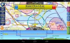
GPS 네비게이션 기능
- 접근 공역, 항공 고시 보, 장애물, 지형 및 기타 위험에 대한 지능형 경고
- 가상 레이더는 모든 접근 기능의 측면에 돌기를 표시하는 방법과 궤도 그들에 관한
- 벡터지도가 자동으로 북쪽에서 항공기를 다음과 최대 추적하거나 코스까지 방향
- 명확하고 간결한 악기는 당신에게 비행 통계를 표시하고 트랙에 당신을 유지하는 데 도움이
- HSI / ILS 장비는 당신이 당신의 계획 노선을 유지하고 접근 일찍 줄 수 있습니다
- 라이브 파일럿 로그인 사용자의 현재 위치에 따라 경로, ETA는, ATAS 유용한 주파수를 통해 진행 상황을 보여줍니다
- TerrainSafe 동적 색상 산악 지형 빠르게 안전한 영역을 식별하기 위해 주위에
- 직접 인근 비행장의 선택에서 선택하여 서둘러 재 라우팅 쉽게 할 수 있습니다
- 접근의 정보 접근을위한 유용한 활주로 다이어그램, TAF, METAR, NOTAM 및 기타 비행장 세부 정보를 보여줍니다
- 관련 경고와 동안 비행 TAF와 METAR의 라이브 업데이트 *
- 확장 활주로 중심선 목적지 비행장 근처에 당신과 같이지도에 자동으로 표시
- 위치의 가까운 잘 알려진 웨이 포인트에 상대적인 위치, 영구 표시가보고
- 터치 및 드래그하여 동안 비행 계획 노선의 손쉬운 변경
실시간 날씨 업데이트에 필요한 * 인터넷 연결 비행 동안
SkyDemon - 버전 4.0.2
(28-01-2025)SkyDemon - APK 정보
APK 버전: 4.0.2패키지: aero.skydemon.skydemonandroidSkyDemon의 최신 버전
다른 버전들


동일 카테고리의 앱

좋아할 만한 것...


